Saturday, October 29, 2011

Egigi Loop

"Neither snow nor rain nor heat nor gloom of night stays these couriers from the swift completion of their appointed rounds" - Postman's Creed -

"Neither rain nor thunder nor lightning nor muddy trail stays the hikers from their Sunday appointed hikes" - Sunday Hikers' Creed -

With determination, Handy, Cutie, "limping" Chops, and Captain Charlie set out to hike the 6.5 mile Esco/Xterra Loop this morning, even though yesterday morning's weather was not encouraging. Not present: Peppy and Giggles continue their bike training, Ms. Vogue is traveling, Juan is MIA, Superman and Wonder Woman are out of commission. So the four of us are happy the morning begins rather bright and sunny. Proceeding on Chalan Savana, passing by the cemetary, the chicken farm, onto the main drag of Isa Road, we continue on to "Esco's" down toward Kingfisher.

At that junction, a revolution takes place as the three hikers want to have coffee at Esco's (Tun Goru) on the way back, which means Xterra is out. In addition, the three hikers do not want to get their shoes all wet and muddy. Handy, the leader, suggests that we take the Egigi Road, which he has wanted to do anyway. CC is amenable to the idea, so we stay on Talafofo Road first and encounter a few bikers practicing for the Hell of Marianas Race.

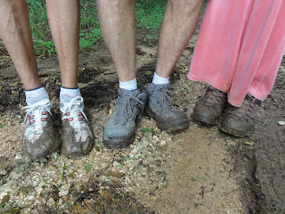
We turn off on Egigi. It is a nice shady trail. Unfortunately, the three hikers come face to face with a large muddy puddle and end up with muddy shoes anyway! At the end of Egigi we stop over at Baby's plant nursery to rest and for Handy and Cutie to spend money. The stop at Tun Goru re-energize everyone, and with end almost in sight, we pick up the pace. Just as we enter the paved road toward the chicken farm, a torential rain greet us with a rather cold shower. but we press on and pick up some star apples at the YWAM garden. One more shower catches us just before we reach home turf, just so we can go inside the house dripping wet!

It is a nice, though mild hike, even though it takes nearly four hours.

Bright and early on Savana Rd.

Cemetary, soon to be moved

Handy trying to remove government property!

Now Handy is thirsty...

Patriotic dog

Lone biker training for HOM

Cute calf hiding in the bushes

Beautiful muddy shoes.

Re-fueling at Tun Guro

Saturday, October 22, 2011

LaoLao

Four of the diehard hikers take off this morning for LaoLao, a third time for Handy, Cutie, and Chops, but the first for Captain Charlie, who is most curious about the cave and the possibility of locating the Sherman tank. Peppy and Giggles are busy biking in preparation for the Hell of Marianas race.

Handy parks his blue car by the first beach, and we proceed on the beach, where it is sandy at first, but becomes more rocky and the tide seems high. But we are alone on the beach to enjoy the sunrise and calm water. Soon we cut through a rock opening setting onto the main coral road. The cave is a short distance from there. Although the cave is only about twenty feet deep and there are steps carved into the dirt, we decide not to go down as the steps are quite slippery. With all our flashlights, we are able to get a good look into the bottom. We will try to enter it during dry season.

Arriving on the next beach, CC takes a photo of the shy fishermen preparing their nets, and then we see a surprising scene of dozens of fishermen and fisherwomen deep in the waters near the ledge fishing for atulai. We stop to chat with some of them and find out that today is a total bust for them, as no one is catching any atulai. Apparently there are barracudas intercepting their catch and snatching the atulai before the people can real them in. But everyone seems pretty good nature about it. Island attitude...

Before running out of beach we decide to cut across a beach front property for the road. As we come to the road, there is a huge puddle, bigger than the ones we have crossed before, so we turn back and decide to hike through the lawn to reach the other side of the puddle. Suddenly a loud voice stops us on our track. The old man who owns the property wants to know what we are doing and where we are going. We greet him warmly and explain our dilemma re the puddle. He becomes friendly as well and tells us he thought we were Russians and lost! After a little chitchat, he gives us his blessing and we are back on our way. We all agree that friendliness begets friendliness.

Our next stop is at the Villagomez (or is it Tenorio) property. What a beautiful piece of land with a spectacular view. Continuing to the end of the trail, we come to the barbwire fence by the 8th hole of LaoLao Golf Course. We almost make it along the fence to enter onto the grounds through a gap between two fences, but don't want to risk falling to our untimely end, as there is a sheer drop just two feet off the fence. We so hope to get a glimpse of the tank, knowing that it is so close yet so far. So we turn back. We will find a way to get on the golf course and locate the tank, one day soon. Upon taking another trail toward the ocean, we discover a set of steps leading to the beach, during low tide. Further on, there is a diving platform that marks the end of that trail. It is all very damp and slippery.

A decision is made, on the way back to the car, to drive up to Kagman instead of back to San Vicente. Unbeknownst to us, that road up is very rough. An SUV could have made it fairly easily. The little blue car is brave and Handy is determined. Despite some seriously loud scraping on the under carriage, and some spinning of the wheels, but with three backseat drivers giving various advice, we all breathe a sigh of relief when we finally hit paved road. That is an adventure we hikers are familiar with! A great hike and more potential trails for the future.
Pointing out the distant view

The Cave...

Handy weighing whether to go in or not

Navigating one of several big puddles, who are those shadow people?

Fishing for atulai

What's today's catch?

Four happy hikers

Sunrise on LaoLao

Sunday, October 16, 2011

Kimikaze

Our plan of hiking down Xterra and the cross island trail falls victim to the torential rain in the past few days. We decide to save that hike for a later and drier day. The FEBC and Kimikaze trail seem a good alternative. The hike is attended by the three musketeers of Handy, Cutie, and CC. Everyone else are either leaving island (Peppy and Ms. Vogue), recovering from injury (Chops), or engaging in other activities (Giggles, Kento, and WonderWoman).

We arrive at the Go-Kart parking lot, remove the baricade which is a new feature at the entrance to the lot, and park. Going up FEBC is a little bit of a challenge, but we know we need the good cardial workout. On the way to Kimikaze, we once again appreciate the beautiful early morning tranquility, mixed with the numerous birds singing, the clear blue sky, and the crisp cool air. We feel really furtunate to have this piece of undisturbed land for our enjoyment. Kimikaze trail is in premium shape. It has been cleared and expanded so it is a pure joy to hike on it. We are so glad to have decided to hike it before the grass retakes the path. At the end of the trail, we choose to forego Autobaun, and turn around back up Kimikaze. Then, instead to going down FEBC, we take the trail behind the golf course. It is a little wet, and we have to negotiate crossing a large pool of muddy water without getting our shoes wet.

Although it doesn't seem like a very long hike, it takes us 3.5 hours. We feel pretty good...

Healthy Handy & Happy Cutie

"Highway" Kimikaze

Golden carpet of fallen leaves

Dead vines similar to those on Cowtown Trail

Handy testing out the new-found water trough

Dynamic Trio

Brown Beauty

Home stretch

Sunday, October 9, 2011

Santa Clause/Cow Town

After several weeks of separation, the hiking group get back together, although unfortunately several diehard members have taken ill: Handy, Giggles, and Ms. Vogue are all down. Four of us meet up at Last Command Post. Despite some foot issues, Chops gamely agrees to take the long route of ascending toward Grotto for the Santa Claus Lane.
On the way, we see two brave bikers struggling mightily up the hill, but also enjoying the beautiful crisp morning air. We notice some strange markings of silhouette shape of snake, runner, star fish and crown appear in sequence on the side of the road. We can't figure out what they mean or what purpose they have served.
With all the catching up on news and "gossip", the uphill climb goes by quickly and we are soon entering Santa Claus Lane. We are surprised to find the farm house, which always had many barking dogs, totally abandoned. Another surprise is finding the vista along the way wide open from the recent demise of the vine population. The dead vines are everywhere. We are now able to see the rock faces and the ravine, and are surprised at how high the rail track is. It is a real pleasure to be able to see deeper into the jungle.
As we near the Cow Town area, we can hear the surfs pounding on the beach, so we decide to check it out. The surfs are rough and loud. We spend some time there to enjoy the scene. Chops, Peppy and Cutie are able to hunt for their glass collection. Chops and Peppy will eventually create inlaid glass collage table tops...
The trails are pretty overgrown and slightly muddy from all the rain we have had recently. Soon we are at Bonzai Cliff and watch white caps on the ocean. The rough seas have not discouraged fishermen from cliff fishing, standing dangerously near the edge. We just hope no one falls in...

What does this symbol mean?

Treasure Hunting...

High surfs at CowTown Beach

One of many busy and creative spiders

The four happy hikers

Very cute Cutie...

Banzai Cliff with ominous looking sky!

Serene KuanYin

We finish the 5.8-mile hike in 3 hours and 25 minutes, feeling pretty good overall...