Saturday, March 30, 2013

Farm Trails

With Handy, Cutie, and Dora off island, Giggles and SpiceGirl entertaining visiting family members, Sunday hiking depends on the four die-hard members: Chops, Jane, Bruiser, and Capt. Charlie to finally take the long awaited hike through the xterra farm trails. We anticipate a long, although not hilly, trek from CC's driveway to Talofofo Road, Egigi and into the farm land.

A pink streak of morning cloud captures the rising sun rays. The dark clouds above look ominous and we full expect rain showers somewhere along the way.

The Xterra trail is surprisingly wet and slippery. At the detour on the trail, near the collapsed portion, Chops takes a slip-and-fall, and appears unhurt and quite happy to land on the soft soil. The rest of us take notice.

After witnessing Chops' graceful fall, Jane and Bruiser make their way carefully down the red mud. 

Evidence of Chops' fall. The rest of the trail is relatively dry. We look for the mango tree, without success.

Glorious sunrise near Camacho's farm.

Onto Talofofo Road. This newly uncovered cave is one which we believe is opened by the group of "cave searchers" recently visiting the island. We decide not to explore this cave today. From Talofofo, we turn into Egigi, past the Babauta ranch. As we are busy talking, we continue on Egigi until we realize that we have missed the turnoff to McDick trail. We back track to the V junction and start on McDick.

The old rickety wooden bridge on this trail has been replaced with a new model, courtesy of PIC. Jane wants to make sure we are aware of this strong new bridge.

After McDick, we are in the Guerrero farm land. We are impressed by this group of healthy looking beetle-nut trees.

Right after the ranch, we enter Ho Chi Minh trail, characterized by the farm land trails. We are really impressed by the hugely expanded farm acreage, beautiful vegetables growing for as far as the eyes can see. Chops is checking out something on the ground.

Looks like sun-dried tomotoes!

cylindrical squash.

Very healthy looking corn stalks, much better than the ones grown in years past. CC has purchased some of the locally grown corn and finds them quite sweet and tender.

Cherry tomatoes hanging down like Christmas ornaments. Currently it is tomato season, and one can find firm and sweet tomatoes in stores and farm stands.

After leaving Ho Chi Minh, we re-enter the boonies and come upon Bananarama, where giant size banana trees dominate the landscape. Jane and Bruiser demonstrate how tall the trees are.

Bruiser sticks his new tongue out. 

We decide to have our snacks before hitting Egigi Road again. The rest of the hike will be on Egigi, Isa, and Savana. We find the large mango tree and spread out our goodies. After filling our tummies, we feel much better. The weather is cool enough so the rest of the open road hike is, although long, not too hot.

A group photo at the driveway. Jane thinks this look like a high school photo shoot. But is CC really that short? Of maybe Chops is just really tall!

This is another long hike, totaling four hours and forty five minutes. Since there is no getting lost, or climbing up boulders, exploring caves, or any such adventurous events, it is still a most enjoyable hike, I think we rate it at least a four -sneaker hike. 

Monday, March 18, 2013

Banaderu Trail

A change of plan brings us to the Banaderu trail for our Sunday hike, partly to show a couple of visitors the rugged jungle, what we call boonies, on Saipan, and the panoramic view, and partly to get back to a more challenging hike. We gather at the parking area across from the Last Command Post at 6 a.m., an all ladies team of enthusiastic hikers looking forward to an exciting adventure: Giggles, Peppy, Chops, Dora, Tojo-a-gogo, Christine (from France), Yoko (from Guam), and Capt. Charlie. Chops is appointed the trail blazer, being more familiar with the lay of the land. The sky is still somewhat dark as we approach the Korean Monument from where the trail begins. Having spotted the first pink ribbon, Yoko surges ahead to lead the way up.

The "Lost Tribe" a.k.a. "Sunday Hikers" lives up to its name and promptly loses its way in the boonies. We climb up and up over boulders, loose rocks, tree stumps and foot-grabbing vines, following pink ribbons that have been set, possibly by the hashers or some other groups. We soon realize that the direction we are going is not the right way. Chops is climbing up a cliff in search of ribbons that will lead us to the trail.

Dora recalls a cave we have passed by during our last hike on Banaderu. We run into this cave, but it is not the same cave. Yoko decides to climb into it to see if there is any interesting objects d'art or a possible crime scene. She finds none.

As we scatter in different directions in search of the trail, some climb further up the cliffs, and some continue down the slopes, Dora and Christine savor a little rest to survey the surrounding. The boonies holds a large number of birds-nest ferns.

Yoko is the first one retreating back downhill and runs right onto the proper trail. We have apparently missed the tree with multiple ribbons and a big orange arrow marking the beginning of the concrete steps. We call out to the rest of the tribe to join us.

Chops and Dora scramble down on all fours.

Tojo-a-gogo is besides herself with glee.

Giggles and Peppy breathe and smile with a sigh of relief.

Back on the trail, Peppy, whose original hiker name is Ms. DeVine, is almost disappointed that the vines of her namesake is almost gone. Two years ago, when we first hiked on this trail, the vines, Cadena de Amor (Chain of Love) had overtaken and covered other trees, threatening to choke them. Peppy came to the rescue by pulling down the, pretty but offensive, vines, hence CC gave her the name Ms. DeVine.

These cute little red berries are used for the eyes of the Bojubo dolls, a very popular local handicraft, for the tourists. The berries, however, are toxic.

Christine delights in photographing all the different kinds of plants and living things on Saipan. Here she looks like a beautiful and happy boonies-fairy.

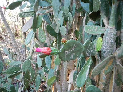
We near the top of Suicide Cliff. Here is a clump of cactus that is well "graffiti" carved, a common practice on these cacti. This plant is blooming.

On top of Suicide Cliff, Giggles is exhausted and not giggling. She takes a little rest before our snack feast.

After satiating with snacks, we gather for this group photo, back row L to R: Yoko, Peppy DeVine, Christine. Front: Capt. Charlie, Giggles, Tojo-a-gogo, Dora, Chops.

Although Dora would have loved to hike back down the trail, we decide to take the road. It's hard to beat this view of the lagoon, as Yoko, Dora, Chops, and Giggles take over the road.

Finally back on Highway 30, we bump into this mail-box like skull of a cow. 

After the long trek down from Suicide Cliff, the hikers arrive back at Last Command Post, and almost immediately get swallowed up by a group of Chinese tourists.

Three hours and fifty minutes, of which almost an hour spent getting lost :-), we give this a great hike of five-sneaker rating. Next time, we will try not to get lost...

Wednesday, March 13, 2013

Nan Madol

After two tough hikes in the past two weeks, we are ready for an easy stroll. This is also planned as a practice hike for Rexplorer to test his mobility after having gone through a series of physical therapy sessions. We choose the Nan Madol Trail for this practice. At 6 a.m. we meet at the Bird Island Lookout: Chops, Rexplorer, Shelly the PT, spouse Chris, and CC. We take the dirt road toward Kalabera Cave.


PT Shelley measures Rexplorer's hip extension before the hike.

An old never-used water pump half hidden in the boonies. One of those projects that never come to fruition. 

Rexplorer and Capt. Charlie prepare for the hike with a basic Foundation stretch. Hmmm, looks like both need to adjust the front knee a little bit.

When we reach the cave, lo and behold, Dr. Hofschneider and his daughter and granddaughter are already there. They have arrived at the lookout before we, and have thought we have gone ahead, so they rush to the Kalabera Cave to meet us. We decide to check out the walls and the deep cavern at the Cave. The Nan Madol trail is just outside of the cave.

Eva, our five-year old hiker has a lot of fun discovering all sorts of interesting natural wonders. Notice the light brown carpet of leaves on the ground. 

A large rock has been lifted off the ground by this tree trunk. Slow and persistent efforts succeed in getting this tough job done!

There are two large kapok trees on the trail, both of them have scattered their fluffy white cotton stuffing all around the ground. 
CC forgets to take a photo of the Wall, where the trail name Nan Madol originates, as we are so involved with discussing the purpose of building the Wall, some say it's for target practice, some say it's for loading sugar trains. No agreement is reached. Someone has to do some research.

Completing the circle hike, we stop at the Bird Island lookout for a group photo, L to R: Chris, PT Shelley, Capt. Charlie, Rexplorer, Chops, Doc. H, Eva, Becky.

PT Shelley makes one more check on Rexplorer's hip, and he comes out with "flying colors". Is that a look of pain or relief?

We continue our hike into the boonies for some exploring. This is one of the interesting root formations that we encounter. 

CC is making Sakau, a Pohnpei drink by squeezing the hibiscus roots. Not really. This root system is so wrapped and twisted, looking like a large cloth being wrung dried. Just another amazing nature's wonder.

This being a nice and easy hike, and enjoyable overall, we give it a Three Sneakers rating. Next Sunday we climb the Banadero Trail from the Korean monument to the top of Banzai Cliff.

Thursday, March 7, 2013

Profile Beach (Old Man)

Having done a pretty tough  hike the previous Sunday, we decide to repeat the feat. Old Man by the Sea (aka Profile Beach) is our target destination. Early dawn finds us gathering at CC's driveway for our trek down Xterra trail. Chops, Dora, Jane (Bruiser is temporarily out of commission), Spicegirl, and CC form the all-girl team. Although there are some clouds in the sky, it predicts a warmer day ahead. We begin our hike.

One of the rewards for early starts is this gorgeous sunrise. After the initial shaded trail, we come upon an open space and is welcomed by the rising sun over the blue water. 

Our next view over the grassy field and across the valley is the sight of "Radar Hill", where for a few years in the 80's, a satellite dish was installed as part of Reagan's Star War preparation. This is gone now, but the name stuck.

Dear Spicegirl shows up with an entirely different regalia of camouflage outfit and a Mao cap. We feel compelled to salute her and address her as General Lee. Dora seems to ignore this momentous occasion.

We turn off from Talofofo Road onto the trail leading to the beach. The original trail having been blocked off by a barbed wire fence, Dora, Jane, and Gen. Lee pick their way carefully on the narrow path for the hill.

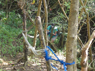
CC descends the steep slope with the help of this blue rope. Today the slope is not too slippery.

Chops is on the next series of ropes to continue down the steep slope.

Further down the hill, Jane is near the bottom, toward the grove of tangled trees and branches.

Dora leads the way to tackle the thickets of branches. It's a bit like Dorothy entering the forest of Yellow Brick Road journey. Watch out for the trees coming alive!

This is definitely tough for Chops as she bends low to avoid being bumped on the head.

The tangled mess of branches goes on and on for what seems like a very long distance. Even shorter General Lee and her troop (Jane and Dora) have to stoop low, but with good humor.


Finally arriving at the beach, and we are rewarded with this profile of an old man in the misty morning air.

The Michael Jackson Fan Club members showing off their one-gloved hands: CC, Jane, Spicegirl, Dora. 

CC forgets the usual tablecloth, so Jane creatively tears up two plastic bags for this makeshift cloth. We are hungry and no matter, we wolf down the snacks in quick order.


Satiated, and happy, we must pose with the old man before the long hike all the way uphill!

Chops decides to use the butt-walk method of going down this slippery hill. Dora keeps an eye on her and gives her the thumbs-up.

After the long climb back up Talofofo Road and onto Xterra, General Lee demonstrates the effectiveness of her camouflage. We are properly impressed.

This is another 4.5 hour hike, and we are all pretty exhausted with the sun and humidity. But it is a very enjoyable. It is a five sneaker hike...Next week we intend to do an easier trek.