Wednesday, October 28, 2015

Coral Ocean Point Beach

An easy and short "hike" is planned for Sunday. The southern coast of the island is the location of Coral Ocean Point golf course and hotel along Agingan Beach. Water at Agingan Point coast is also famous for being the location for an unhappy end of the Spanish galleon Nuestra Senora de la Concepcion in 1638 while sailing from Manila to Acapulco. It was laden with Chinese silk, porcelain, ivory, camphor, spices, and precious jewels. When near Saipan during a storm (typhoon) it hit the reef of the Agingan coast and broke apart in the rough water, leaving a trail of treasures and stoneware in the deep water. Some of the treasures were recovered in 1987, and a number of pieces were displayed in the Saipan museum. Later attempts to recover more treasure yielded little or none.
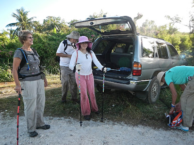
Sunday morning finds eleven hikers meeting at the parking lot of the C.O.P. : RedEye, Cutie, Ewok, Effrain, Martha, CB, Chops, Thor, Sparky, Giggles, and CC, ready for a stroll.

CB, Cutie, Chops actually stroll down the wide lane through the golf course. The day is nice and sunny, despite the remaining haze still lingering, as a result of the multitude of fires in Indonesia and Papua New Guinea.

A strange sight of this light pole being wrapped around by a branch. We haven't been able to quite figure out how the branch manage to embrace the light pole, apparently during a storm.

Thor, Martha, Ewok, Giggles, Efrain, and Sparky approaching the beach.

Just as we reach the beach, we are approached by a super friendly person, greeting everyone with "Welcome to Saipan!" as if we were tourists. Then the three ladies are "trapped" by his enthusiastic attention. They are eventually able to extract themselves from him.

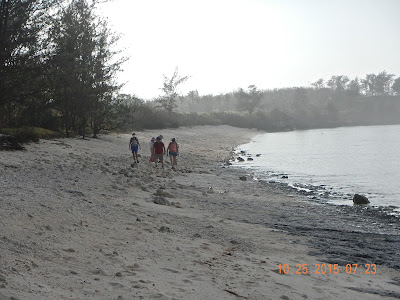
A very nice beach, quiet and clean. Lots of washed up glass pieces for Chops to collect and create a table top for entertaining friends.

Thor, Cutie, RedEye, Sparky, CB taking their time to enjoy walking and looking down at interesting finds on the beach. They are slowly approaching the bunker.

Giggles walking on top of the breakwater rock wall built in front of the bunker.

Ewok at the entrance into the bunker, making sure everyone knows how to get there.

The Japanese bunker is being termed a "blockhouse". The picture shows a bunker in a cleared area. It is built based on a German plan, during the final days of the war.

Cutie cautiously looks into the entrance.

Opening on top of the bunker for ammunition storage.

RedEye carefully inspects the interior of the bunker that has four cannon positions. The bunker never involves in war action.

Thor approaching the bunker.

Some very interesting coral fossil designs on the beach.

Curious Sparky digging around the beach site finds this piece of old blue-and-white porcelain encrusted with coral. Knowing that the Concepcion was carrying much Chinese goods such as silk, rugs, and porcelain, Cutie takes it home to research the origin of this rare find.

Treasure salvage in 1987 off the coast of Agingan Bay.

Sketch of Nuestra Senora de la Concepcion.

An ancient Chamorro mortar called "lusong" displayed on beach side along with two story boards.

Ewok reading the sign that explains the existence of an ancient Chamorro village located at this site where the Lusong is found.

After we walk on the beach to the far end and to the bunker, we climb back on the road and double back to the palapala for our snacks. Lively conversations and delicious snacks cap off this easy and leisurely walk.

We decide to use this photo taken before our hike as we look more fresh! Back row: Thor, Ewok, Sparky, RedEye, CB, Chops, Martha. Front row: CC, Efrain, Giggles, Cutie.

The 2.5 hour hike is very pleasant and enjoyable. 

Wednesday, October 14, 2015

Naftan, What Happened?

We are curious to find out what has happened to one of our favorite trails from Hawaiian Rock quarry to Naftan Point, the southern most tip of the island. On Sunday 10/11/15 five of us gather at the trail head to start another adventure in our continued quest to explore the condition of Naftan trail. 

It begins with a little overgrown grass on the trail, so we are hopeful that perhaps it will continue thus all the way. Chops, Thor, Cutie, and RedEye seem a little bit concerned. 

Soon tall grasses are replaced with an assorted other bushes, and lots of vines. Suddenly RedEye disappears, having tripped over a fallen branch and gotten tangled in vines.  Cutie and Thor wait for him to extract himself and get up.

The amazing vine attack. For as far as one's eyes can see, the trail and all the surrounding areas have been completely overtaken by this most invasive plant. The large clumps on both sides of the trail are actually trees covered and choked by the vines. 

Up to this point, it appears that someone has partially cleared the trail, so Chops, Cutie, and RedEye are able to continue the hike.

A little tunnel is cleared for access. Chops makes it on her hands and knees.

It's apparent that the trail is getting thicker even though it is still passable.

We note a cliff that we have not seen before when the boonies are still thick and well. 

Another little tunnel for a crawl through. RedEye is almost on the other side.

Cutie chooses to employ a squat and walk technique.
After we make it to the other side, we realize that the trail is completely covered and we decide not to risk getting lost into the vine-covered boonies. This area has a large expanse of trees and steep drops. We turn back.

We decide to get back into the car and drive to the top of the Obyan Road, from there we can walk to the beach.

Obyan Road is still very rough and gauged out, but we enjoy walking in the open and anticipate a fun visit to the beach.

Obyan Beach. It is beautiful and quiet. Water is calm, sun is out, gentle breeze is cooling us. It's a nice break from crawling in the boonies! 

Taking a few minutes for snacks and relaxation. We could stay here all day!

Cutie, CC, RedEye, Thor, and Chops satisfied with finding out what happened to the Naftan trail, though not happy about the prospect of a long and difficult recovery process the trail will need.

Cadena de Amor, Chain of Love vines. Beautiful flowers, but very invasive and pesky.  

What is Chops doing? Hiding from the press? No, just confirming that her shirt smells mildewy! :-)

Although we are not able to go through the Naftan Trail, and sadden by the loss of another hiking favorites, we are happy to be able to still enjoy Obyan Beach.  


Wednesday, October 7, 2015

Sound of Music Post-Storm

We wonder if one of our favorite hiking trails is passable. The circular Tapochau-Sound of Music-Upper XTerra-Waserak-Tapochau is a challenging hike, but also very scenic. We decide to try it and see how far we can go before having to turn back.
We meet on Mt. Tapochau Road just outside of Coral Isle condo, at 6:15 a.m. on Sunday. Six of us, including two new hikers take up the challenge: Chops, Sparky, Ewok, Tom, Edna, and CC begin the uphill climb.

The recently graded road makes for an easy start up the hill.

This stretch of the road gets pretty steep. Here Tom, Edna, and Sparky soldier on, with Ewok and Chops braving the hill.

Finally, we reach Chief Aiken Road where we turn off, passing this big flatbed truck. 

Ewok takes a tumble on the slope covered with loose rocks. 

A minor road block of a puddle. We stop to decide how to cross over.

Ewok decides to tread across the middle lane which turns out mushy up to his ankles. We enjoy watching Ewok's balancing act.

Notice there is only one set of big-foot prints. The rest of us walk on the side of the trail and make it to the other end dry and clean. The trail toward Sound of Music is still passable.

Arriving at the field of Sound of Music. The view of LauLau Bay is still fantastic. From the field we continue onto the narrow trail west toward the view point of Chalan LauLau and Garapan. The trail is full of mimosa.

We reach a big fallen ironwood tree. Here we are temporarily lost. But not for long as the trail continues on the other side of the tree. Edna and Chops make their way over some fallen branches.

Sparky tries to break this branch, but concludes that it will make no difference. We continue on this narrow mimosa-filled trail until we reach a point where we have a glimpse of Chalan LauLau, but not able to continue through the very tall sword grass. Here we decide to turn around.

On the way back, these hikers start to stomp around like mashing grapes for making wine.

Then they walk around as if searching for some lost treasure.

This is the end result of their hard work: a nice and flat sitting area for our snack time rest!

Tom and Edna checking out the wild orchid plant. We enjoy the sun and breeze and fill ourselves with snacks before retracing our steps all the way back down to Coral Isle parking.

A short and sweet three-hour hike with Edna, Tom, Chops, CC, Ewok, and Sparky.