Sunday, August 28, 2011

Almost Naftan

After much discussion on the logistics of hiking to Naftan and how to connect from the upper trail to the lower trail and Obyan Beach, we caravan to Hawaiian Rock to begin our hike to Naftan Point and in search of the connecting trail. An enthusiastic group of eight, including Handy, Cutie, Chops, Giggles, Peppy, Juan, and Vorasuda (who is christened with her hiker nickname of Ms. Vogue and appears in her matching yellow outfit), and Captain Charlie.
After nearly a weeklong "rainstorm", this morning the sky is bright and sunny. The grass has grown taller on the trail and a little muddy here and there. The rain has also brought out numerous wild mushrooms, some of which we have never seen before. 
The side trip to the left brings us to the mysterious cliff with the "carved out" opening that slopes down to the foaming shore. But there is much evidence that some kind of battles must have occured there. The ground is strewn with small pieces of metal of unknown origin.
To continue our search for the elusive bikers trail that connects the upper trail to the lower trail, Giggles and CC both whip out their pink ribbons in preparation to marking the trail. Unfortunately the trail remains elusive and we never complete our plan of romping on Obyan Beach. Instead, we explore.
On both sides of the trail, we find large caves with man-made rock walls, metal barrels, storage alcoves, and bottles. Also clearly visible are bullet holes on the outside walls of one of the the caves, some of which still have bullets lodged inside. One can imagine the fierce fighting in this area and the miserable living condition the soldiers must have endured. We also stumble onto several large structures for gun placements and storage units still quite intact. Near the trail is a double-section water tank that has been blown out from the inside, showing a large hole with rebars bending ourward from the impact of the bomb. Speaking of bomb, there is a sizable bomb laying on the rocky trail off the caves, completely intact and marked with a red ribbon as a warning sign. Ms Vogue, who innocently, nearly picks it up until we all scream for her to keep away! :-)
Another detour brings us to an observation platform where we can see the airport, Obyan Beach (as close as we can get to it today), and the island of Tinian.
Both exploration detours bring us back to the main trail. Everyone decides that we will save the remaining hike to Naftan Point, where the big gun is, for another Sunday. We are tired but very happy with the adventurous nature of this hike that fulfills our curiosity and makes us aware of how much important and interesting historical past this island has.


Today's Frankenstein Speak: Spatacio for Pistachio 

Sunday, August 21, 2011

Stuck Between Two Rocks


Sunday Hikers luck out once again. Despite pouring rain on Friday, Saturday, and Sunday afternoon, Sunday morning turns out dry and cool. Nine hikers (Handy, Cutie, Peppy, Giggles, Clark Kento, Wonder Woman, Capt. Charlie, Narumi, and Alice) congregate at the Last Command Post for a tour to the "mysterious cave" at the base of Suicide Cliff.
The entrance to the trail head is easy to miss, but it is just about two hundred feet from the big banyan tree at the intersection of Middle Road and Kalebera Road. Once we enter the trail we find it thick and dark, even though we are still near the main road. The first find is a large foundation of unknown purpose. Following the well marked pink ribbons, we meander through tall grass and a field of pretty bushes with little red berries, and then stomp through a big patch of "mother-in-laws tongues", which are sharp-tipped but fortunately not thorny, a comfort to many a daughters-in-law! 
The trail comes to a barbed wire fence enclosing a large field with no animals. We begin a gentle climb and come to a big tree under which are scattered numerous broken ceramic ware and beer bottles, some of which are still intact. These are of Japanese origins and the tree appears to be a favorite "party" spot. 
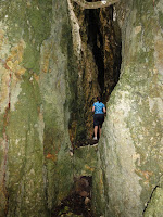
Soon the trail brings us back to the fence and we parallel the fence all the way up to the cliff face. Finally, the path along the cliff face leads us to the "cave" which is really more a crevice. It is a very narrow opening between two giant rocks. After all the Oooohs and Aaaaahs, and despite some misgivings, everyone succeed in negotiating through the the crevice which is about a hundred feet long. At one point, one can see a pretty large rock stuck about twenty feet overhead, an obvious rock fall during an earthquake! We see a tin bowl, with a Japanese navy emblem, resting on a little ledge. As the hiking rule reminds us, we enjoy seeing the relics and leave them where they are for others to enjoy also.
After exiting from the trail, we head uphill to the Grotto. There Peppy, Giggles, Clark, and CC decide to go down to the pool and the rest decide to stay on the observation deck. After gingerly hanging onto the rail as we climb down each step, and watching some young kids bounding down the same steps, we reach the bottom and as always, marvel at the cave and the crashing waves. On the way up we count the number of steps. There are 111 steps. Our final trail is the Santa Claus Lane. It is a "virgin hike" for WW, Narumi, and Alice.  
Although the total distance we have covered is about five miles, it take us four hours as we have taken a rather leisurely pace, and everyone enjoys it!
We have a wealth of Frankenstein-Speak today: Norstrom (for Noisom, my neighbor); Atemono (for Atemoya, also insists it is a sour sap); Totomono (for Taotaomona). We love you, Handy!

Sunday, August 14, 2011

Forbidden Island


It is a great day for our largest group of hikers to assemble, in two sub-groups, for a hike to Forbidden Island. The first group of Handy, Cutie, Chops, Clark Kento, Wonder Woman, Clark's guest Narumi, and Captain Charlie, arrives at the trail head and ties a pink bow on a tree limb for the second group to find their way. We take off down the trail right away.
The first panoramic view of the Island is again breath-taking. With the sun just rising, the sky blue and the ocean glistening, one never tires of the scene. Then comes the hard descent that takes a bit of negotiation, and at the steep drop-off Handy whips out the rope he has brought to extend the existing rope. Chops, although worries that her rope tying skills may not be sufficient, puts in a strong knot for the team.


Everyone breathes a sigh of relief as we finally touch down on the beach. After a short break as we sit and enjoy the crashing waves, or search for old broken glass pieces, or just wander around, we decide to move the camp to the north end by the pool where it is shaded.
Just as we begin to proceed, we notice a group of hikers snaking down the narrow path, but they are too far for us to see who they are, until Peppy appears to bring up the rear of the new group of Tara, Verusuda (she who has an all matching purple ensemble), Juan, Kyle, completing an even dozen of today's hiking expedition.
The number and variety of snacks are impressive. As no one wants to carry them back up the hill, everyone is encouraged to enjoy them as much as possible. A group of high school kids also decide to gather at the pool area for a swim, so we enjoy watching them enjoy themselves.

While sitting around, we discover a rock formation that amazingly resembles a turtle. A photo is taken to memorialize this discovery.

Having delayed for as long as possible for the trip up, we begin the ascent. Tara, Verusuda, and CC lead the way, and part way up Tara and Verusuda take off and CC waits for Clark and Narumi. As always, the way up is a lung-busting challenge. After everyone shows up at the top, we all agree that it is a short but great exercise. We also may have more hikers to join us on a regular basis.

A post note: we hear later that the Kagman area we drive through this morning is the scene of a discovery of human bones, possibly of one of the missing girls.

This week's Frankenstein-speak: Porker Parlor

Monday, August 8, 2011

Xterra/Talofofo

Our plan of beach combing at Jeffrey's Beach comes to a quick end with the torrential rainfall on Saturday. One of the biggest problems on several flood drenched beaches is the infestation of leptospirosis. We decide to keep our starting point at Xterra and then see what happens.
In attendence are Handy, Cutie, Chops, Giggles, and CC. The others, namely Clark, WW, and Peppy are involved in the Tournament of Champions.It is cool and overcast, as we duck under overgrown sword grass and dodge the thorny mamosa on the Xterra trail. We have to pick our way carefully to avoid tripping or twisting our ankles on the uneven path hidden under tall grass. At the famous and newly cleared crash-and-burn drop off, we wisely take the long way around. When the trail finally opens up, we find ourselves in the beautiful meadow-like path, and through a canopy of trees toward the farm at the end of the trail, where a turkey awaits us.
Onward to KingFisher on Talofofo Road. It's up and up and up the big hills, a real test to our cardial power. We take a short stop at the entrance of Jeffrey's Beach and decide not to venture further through the puddles.
Part way up Talofofo, we discover another trail head that leads to a stream bed, which is currently dry. We may take a hike on that trail in the future. A quick rest stop at the trail head to Old Man by the Sea, another future hike, soon finds ourselves drendged in a rain shower, except for Cutie who whips out a little umbrella, looking dry and happy. Maybe we should change Cutie's name to EverReady Bunny!
With a choice of either taking Egigi (longer hike) and visit with Babe, or continue on Talofofo, Handy makes a decisive choice of continuing on the main road.
At the top of the hill, we stop at Esco's for a group photo and for Cutie to have a cup of coffee and some snacks. On the way near the chicken farm, another discovery: Giggles points out a strange spiky fruit that none of us recognize. They look like baby durians, but the tree looks too small for a durian tree which is tall with a very straight trunk. Chops will research and report.


The hike takes roughly three hours.


P.S. Chops reports in that the fruit is called Atemoya. Read her email message and Handy's message for details.
.